More about Surveyor General diagrams
-
Select a property by searching or clicking on or near a property on the map.
-
Open all SG Diagram information of the selected property from the pop-up window, by clicking on the SG diagram tab (second from the left). All SG Diagrams related to the selected property will be displayed in the window. A preview window will show preview images of the available diagrams.
-
Select the diagram that you want to view from the preview window.
-
The selected diagram will be enlarged to full screen and includes showing document number and diagram type.
-
To Geo-reference the diagram, click on the Toggle Georeference View (insert icon),
the Toggle Geo-reference Edit button appears below, click it.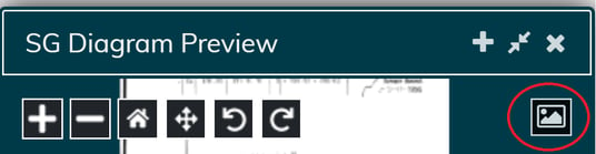

-
Zoom into the diagram and select the first point, ensure it is a corner or distinct marker so that it can be found on the map too.
-
Move to the map and match the exact point on the diagram to the map, click.
-
Repeat these steps 3-4 times ensuring that the points are spread well across the diagram.
-
To finish the geo-reference click on the Toggle Georeference Edit button again.
-
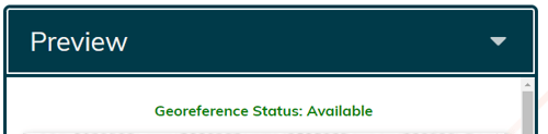
Returning to the SG Diagrams window you will notice that the Geo-reference Status above the diagram now reads in Queued in Yellow.
-
Upon completion, it will read ‘Geo-reference Status: Available’ in green.
-
To view the geo-referenced diagram, ensure the base layers are turned to none and then select the Toggle Geo-reference View button.