---
title: Comparing Deeds, Valuations, Financial Accounts (Municipal and District) & Map
description: Using Allotment code, Stand and portion per property as the key to synchronize these five sources of property information, mismatches need to be monitored and corrected by the municipality to reduce queries and improve revenue collection.
---
[Skip to content](https://help.1map.co.za/knowledge/comparing-deeds-valuations-financial-accounts-map-sg#main-content)
English
Show submenu for translations
![logo-whte-1.png\]](https://help.1map.co.za/hs-fs/hubfs/logo-whte-1.png?height=50&name=logo-whte-1.png)
Open main navigation
Close main navigation
- English
Show submenu for translations
- Go to 1map.co.za
Go to 1map.co.za
Hello. How can we help you?
- There are no suggestions because the search field is empty.
1. [Help Centre](https://help.1map.co.za/knowledge?hsLang=en)
2. [Financial Integration for a Municipality](https://help.1map.co.za/knowledge/financial-integration-for-a-municipality?hsLang=en)
3. [Phase 2 - Convert & Map Data (Data Integration)](https://help.1map.co.za/knowledge/financial-integration-for-a-municipality?hsLang=en#phase-2-convert-map-data-data-integration)
# Comparing Deeds, Valuations, Financial Accounts (Municipal and District) & Map
## Using Allotment code, Stand and portion per property as the key to synchronize these five sources of property information, mismatches need to be monitored and corrected by the municipality to reduce queries and improve revenue collection.
**Filter: 1a - In Deeds (Ctrl Dn - Missing in SG)**
Looking at # columns, there should be at least 1x ‘1’ per row.
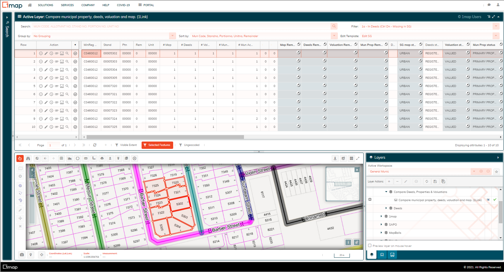
Question we are trying to solve:
**WHAT APPEARS IN DEEDS BUT IS MISSING ON THE MAP?**
Sort By: Distr Code, Mun Code, Allotmntno, Standno, Portionno, Remainder etc.
Process to follow:
1. Make the layer active and open the data grid;
2. Click on the first entry & then click **CTRL** **↓** - you should be moved to the next entry that has no geometry;
3. Inspect the entry above and below it (it is in numerical order - stand no sequence - so they should be the number above and below it) - investigate;
4. Check the SG diagrams either by clicking on property or Manual Search in the Gauteng office;
1. Does it exist in the SG?
2. Is there anything on the diagram about what happened? Ie. cancelled - follow the train to find what the new stand number is;
3. Check the comments on the SG diagrams too.
5. Check the imagery - is there something there?
6. If it has been consolidated/subdivided then open **Deeds Summary** & check that it is there **(if the property is brown then it is in deeds)**;
7. *UPDATE Map Remarks*;
8. In SG Remarks put in the new stand number & a comment on what seems to have happened.
**SG MAP REMARKS**
Subdivision not Registered - SD NOT REG
Consolidated not Registered - CONS NOT REG
Subdivision - SD “new stand no”
Consolidated - CONS “new stand no”
Scenarios:
- - A property has been replaced - it remains on the system but it does not actually exist;
- Original land parcel deleted - the SG should never have deleted it and they need to recapture the deleted item;
- No stand no. - ignore;
- Sectional Schemes - ignore;
REMEMBER:
- Numbers grow incrementally BUT if there is a consolidation/subdivision the new property will be allocated the next available no and this can mess with the sequencing.
- You can search for the erf in the left hand search bar
- Ignore sectional schemes
- If consolidated or subdivided check deeds to see if it is registered.
- ONLY edit the entries selected by the CTRL down arrow
**Filter: 2a - In Deeds (Missing in Mun Prop) **
Question we are trying to solve:
**WHAT APPEARS IN DEEDS BUT IS MISSING FROM THE MUNICIPAL SYSTEM?**
Sort By: Distr Code, Mun Code, Allotmntno, Standno, Portionno, Remainder etc.
Process to follow:
1. Make the layer active and open the data grid;
2. Ensure you have the correct Aerial Imagery selected;
3. Start from the top of the list and move all the way through **dealing with all entries;**
4. Ignore entries that are rural/farmland (Minor Region Code ends 0000) & properties that are ungeocoded;
5. Inspect the selected property to see what the current activity is;
6. *UPDATE Mun Prop Remarks*;
7. If there is a whole suburb, neighborhood or area that seems to be missing - notify Derryn as this could be an incorrect Minor Region Code.
**Filter: 4a - In Valuation (Missing in Municipal Property)**
Question we are trying to solve:
**WHAT APPEARS IN VALUATION BUT IS MISSING FROM THE MUNICIPAL SYSTEM?**
Sort By: Distr Code, Mun Code, Allotmntno, Standno, Portionno, Remainder etc.
Process to follow:
1. Make the layer active and open the data grid;
2. Ensure you have the correct Aerial Imagery selected;
3. Start from the top of the list and move all the way through dealing with all entries that are blank in their *Mun Prop Remarks* column;
4. Ignore entries that are rural/farmland (Minor Region Code ends 0000) & properties that are ungeocoded;
5. Inspect the selected property & then write down it’s Minor Region Code (MRC) & Stand No (stand no needs to be 8 digits so if the stand no is 365 then it should be 00000365);
6. Move to the Location Address Layer - search for the property using the MRC & Stand No.
7. Investigate to see if the property can be found in the Location Address & if it has a remainder or is the parent parcel;
8. *UPDATE Mun Prop Remarks* according to what was found in step 7;
Sample remarks about our conclusions:
SG TO CAPTURE
MISSING
SUBDIV NOT REGISTERED
CONSOL- NOW “NEW STAND NO”
INVESTIGATE - PTN
VACANT
ROAD
ROAD (ADJACENT)
POS
ALLEY
MISSING - SS
BULK ACCOUNT - BILLED AS UNIT 00000
INVESTIGATE - NOT ON MAP - HAS A SG KEY (appears when you search on location address but is not geocoded)
INVESTIGATE - NOTHING SHOWN ON MAP ( nothing appears when search on location address)
INVESTIGATE - FARM PROPERTY - NO BILLING
INVESTIGATE -VACANT. NO BILLING - SURROUNDING PROPERTY HAS BILLING
PTN1 & REM, BUT NO PTN 2
PTN 1, NO PTN 2
If there is a whole suburb, neighborhood or area that seems to be missing or incorrect - notify Derryn as this could be an incorrect Minor Region Code.
**Filter: 7a - In Municipal Property (Missing in SG Ctrl Dn)**
Question we are trying to solve:
**WHAT APPEARS IN MUNICIPAL PROPERTY BUT IS MISSING FROM THE MAP?**
Sort By: Distr Code, Mun Code, Allotmntno, Standno, Portionno, Remainder etc.
Process to follow:
1. Make the layer active and open the data grid;
2. Ensure you have the correct Aerial Imagery selected;
3. Click on the first entry & then click **CTRL** **↓** - you should be moved to the next entry that has no geometry;
4. Search for the property in the erf number search bar on the left hand side of the screen;
5. Investigate to see if the property can be found & then determine the outcome;
6. *UPDATE* **Mun Prop Remarks** and/or **Map Remarks** according to what was found in step 5;
*if the PTN NO NOT FOUND we fill it in both SG and Mun columns.*
| STAND NO INVALID | 9999, remainder, any other rubbish |
| --- | --- |
| STAND NOT FOUND | Erf seems valid but can’t be found when searched for |
| PTN NO INVALID | |
| PTN NOT FOUND | Stand no found but ptn not found |
| CONSOL - NOW nnnn | |
| SD - NOW nnnnn | |
| REPLACED - nnnnn | |
| SS - nnnnn | |
| SG TO CAPTURE | |
| RESEARCH | |
| CANCELLED - NOW nnnnn | |
| RELAYOUT - NOW nnnn | |
| | |
**Filter: 3 - In Deeds (Missing in Valuation)**
Question we are trying to solve:
**WHAT APPEARS IN DEEDS BUT IS MISSING FROM VALUATION ROLL?**
Sort By: Distr Code, Mun Code, Allotmntno, Standno, Portionno, Remainder etc.
**Filter: 2a - In Deeds (Missing in Mun Prop) **
**Dealing with “Missing” Properties**
Question we are trying to solve:
**WHY IS THIS PROPERTY MISSING - IS IT OUR MISTAKE OR IS IT ACTUALLY MISSING FROM THE MUNICIPAL SYSTEM?**
Sort By: Distr Code, Mun Code, Allotmntno, Standno, Portionno, Remainder etc.
Process to follow:
1. Make the layer active and open the data grid;
2. Ensure you have the correct Aerial Imagery selected;
3. Start from the top of the list and move all the way through dealing with all entries that say “Missing”;
4. *UPDATE Mun Prop Remarks*;
5. If there is a whole suburb, neighbourhood or area that seems to be missing - notify Derryn as this could be an incorrect Minor Region Code.
- [Getting Started](https://help.1map.co.za/knowledge/getting-started?hsLang=en)
- [Finding a property](https://help.1map.co.za/knowledge/finding-a-property?hsLang=en#main-content)
- [Basic](https://help.1map.co.za/knowledge/finding-a-property?hsLang=en#basic)
- [Available Search Methods](https://help.1map.co.za/knowledge/finding-a-property?hsLang=en#available-search-methods)
- [Property Information](https://help.1map.co.za/knowledge/finding-a-property?hsLang=en#property-information)
- [Q+A](https://help.1map.co.za/knowledge/finding-a-property?hsLang=en#qa)
- [Utilities and Tools](https://help.1map.co.za/knowledge/utilities-and-tools?hsLang=en)
- [Layers](https://help.1map.co.za/knowledge/layers?hsLang=en#main-content)
- [Layers](https://help.1map.co.za/knowledge/layers?hsLang=en#layers)
- [Workspaces](https://help.1map.co.za/knowledge/layers?hsLang=en#workspaces)
- [Survey Diagrams](https://help.1map.co.za/knowledge/survey-diagrams?hsLang=en#main-content)
- [Diagrams](https://help.1map.co.za/knowledge/survey-diagrams?hsLang=en#diagrams)
- [Survey Records](https://help.1map.co.za/knowledge/survey-diagrams?hsLang=en#survey-records)
- [GeoRef](https://help.1map.co.za/knowledge/survey-diagrams?hsLang=en#georef)
- [DALRRD](https://help.1map.co.za/knowledge/survey-diagrams?hsLang=en#dalrrd)
- [Bookmarks](https://help.1map.co.za/knowledge/bookmarks?hsLang=en)
- [NetworkManager Guide](https://help.1map.co.za/knowledge/networkmanager-guide?hsLang=en)
- [Spatial Editing](https://help.1map.co.za/knowledge/spatial-editing?hsLang=en)
- [Attribute Editing](https://help.1map.co.za/knowledge/attribute-editing?hsLang=en)
- [Printing](https://help.1map.co.za/knowledge/printing?hsLang=en)
- [Exporting Data](https://help.1map.co.za/knowledge/exporting-data?hsLang=en)
- [Uploading Your Own Data](https://help.1map.co.za/knowledge/uploading-your-own-data?hsLang=en)
- [Collaborate with MapBall](https://help.1map.co.za/knowledge/collaborate-with-mapball?hsLang=en)
- [1map Mobile](https://help.1map.co.za/knowledge/1map-mobile?hsLang=en#main-content)
- [read more](https://help.1map.co.za/knowledge/1map-mobile?hsLang=en#read-more)
- [Getting Started](https://help.1map.co.za/knowledge/1map-mobile?hsLang=en#getting-started)
- [Mobile application (for Private Client)](https://help.1map.co.za/knowledge/mobile-application-for-private-client?hsLang=en)
- [Frequently Asked Questions](https://help.1map.co.za/knowledge/frequently-asked-questions?hsLang=en)
- [New Features](https://help.1map.co.za/knowledge/new-features?hsLang=en#main-content)
- [May 2023](https://help.1map.co.za/knowledge/new-features?hsLang=en#may-2023)
- [October 2022](https://help.1map.co.za/knowledge/new-features?hsLang=en#october-2022)
- [September 2022](https://help.1map.co.za/knowledge/new-features?hsLang=en#september-2022)
- [Earlier](https://help.1map.co.za/knowledge/new-features?hsLang=en#earlier)
- [1map Embeddable Viewer](https://help.1map.co.za/knowledge/1map-embeddable-viewer?hsLang=en)
- [Financial Integration for a Municipality](https://help.1map.co.za/knowledge/financial-integration-for-a-municipality?hsLang=en#main-content)
- [Phase 1 - Obtain Data](https://help.1map.co.za/knowledge/financial-integration-for-a-municipality?hsLang=en#phase-1-obtain-data)
- [Phase 2 - Convert & Map Data (Data Integration)](https://help.1map.co.za/knowledge/financial-integration-for-a-municipality?hsLang=en#phase-2-convert-map-data-data-integration)
- [Internal](https://help.1map.co.za/knowledge/internal?hsLang=en)
- [1map Subscriptions](https://help.1map.co.za/knowledge/1map-subscriptions?hsLang=en)
- [Quidity](https://help.1map.co.za/knowledge/quidity?hsLang=en)
- [Emalahleni](https://help.1map.co.za/knowledge/emalahleni?hsLang=en)
- [CityManager](https://help.1map.co.za/knowledge/citymanager?hsLang=en#main-content)
- [Service Delivery](https://help.1map.co.za/knowledge/citymanager?hsLang=en#service-delivery)
- [Mobile](https://help.1map.co.za/knowledge/citymanager?hsLang=en#mobile)
- [User Management](https://help.1map.co.za/knowledge/user-management?hsLang=en)
- [1map Widget](https://help.1map.co.za/knowledge/1map-widget?hsLang=en)
- [FiberTime](https://help.1map.co.za/knowledge/fibertime?hsLang=en#main-content)
- [Desktop](https://help.1map.co.za/knowledge/fibertime?hsLang=en#desktop)
- [SG Lodgements](https://help.1map.co.za/knowledge/sg-lodgements?hsLang=en)
- [Pvt](https://help.1map.co.za/knowledge/pvt?hsLang=en)
- [RevenueManager](https://help.1map.co.za/knowledge/revenuemanager?hsLang=en)
[](https://help.1map.co.za/?hsLang=en)
1map Help Centre
Copyright © 2026, 1map Spatial Solutions (Pty) Ltd